This week's theme from Amy Johnson Crow is "Map It Out"! I wrote about my 5th great grandfather, James Ferguson, a Revolutionary War soldier last year and described his life according to some of the documents of the time. You can read that here, if you like:
https://regnirpsstories.blogspot.com/2018/07/james-ferguson-revolutionary-war-soldier.html. But I have never actually "mapped" the places that he lived. So today, I am going to locate these places on historical maps and then overlay those sites onto a modern map to get a better sense of all the places he lived. For a Colonial era man, he really "got around"! But according to my research, moving "west" and into the "wilderness" areas of the new country was "in the blood" of these independent thinkers whose ancestors had so recently come from their homeland of Scotland!
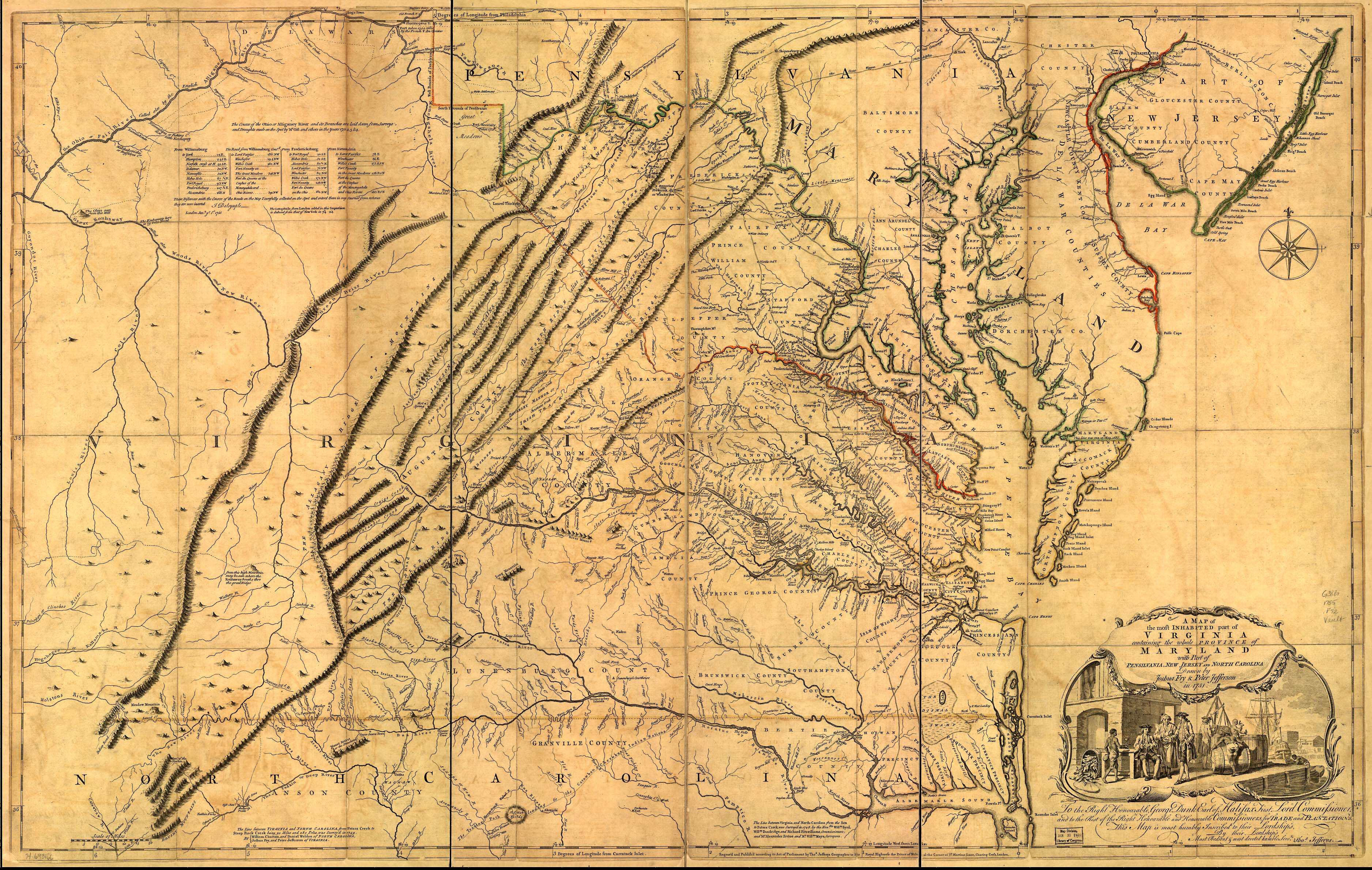
Here is a map of Virginia about 1751.
Right where the red line (border between the colony of Virginia and the colony of Maryland) dips the lowest, is found Orange County, where James was born May 30, 1752. "Orange County" is underlined in yellow.
Here is the 1751 map overlaid on a 2019 map of Orange County. The light green lines are the current county lines. You can see that Orange County is much smaller today than it was in 1751.
About 1782, when James was about 30 years old, and after serving in the Patriot Army, he moved to North Carolina. We have no specific records that reflect which county he might have lived in or if he was already married before moving or met and married Martha Ann Hogge in North Carolina. While living in North Carolina, James and Martha had two children we know about, Jane, born about 1784 and Joshua, born about 1785. Joshua is my 4th great grandfather!
About 1788 James moved his family to South Carolina. We know that they lived in Lancaster County, South Carolina because they are listed in the 1790 and 1800 censuses. Here is a map of South Carolina in 1800 showing the locations of the counties. Lancaster County is just to the right of center on the North Carolina border.
Here is an 1800 Map of Lancaster County, outlined in black and labelled "Lan" with an overlay of a 2019 map showing the current counties, outlined in green and light blue for the border between North and South Carolina. You can see that the county boundaries are very similar. So far, I have not been able to pinpoint the exact location of James's land in Lancaster County.
According to the 1833 Revolutionary War Pension Application, James and his family lived in South Carolina about 18 years, so they must have moved on to White County, Tennessee about 1806. According to records, James and Martha's daughter, Nancy, was born January 1, 1807 on the "Caney Fork of the Cumberland River, White County, Tennessee." I was very lucky to find a map of the Caney Fork area of the Cumberland River that includes Native American Trails from an 1832 map from the Smithsonian.
Here is that Native Trails map with a 2019 map of the Counties nearby, including White County. The river running along the southern edge of White County in the 2019 map is the Caney Fork.
Here is a map of White County, Tennessee (black borders) with 2019 county borders overlaid (green borders).
By 1830, James and his family moved west again; this time to McNairy County, Tennessee. James and his sons, John, Hiram and Joshua are found in the 1830 census and lived west of the red pin on the map above, near current day Sulphur Springs Cemetery. McNairy County had been created in 1823, so it was on the western front of the wilderness. And that was a perfect place for these Scots! Here is a map showing the 1824 county lines (black) compared to the 2019 county lines (green).
According to the Pension Roll of 1835, James Ferguson was living in Lawrence County, Territory of Arkansas and receiving a pension of $80 per year, which had commenced on March 4, 1831. In 1832, Congress had "passed the Pension Act of 1832 allowing pensions again based on [Revolutionary War] service and made widows of veterans also eligible to receive pension benefits." Source: https://www.familysearch.org/wiki/en/Revolutionary_War_Pension_Records_and_Bounty_Land_Warrants.
James had applied for this Pension on May 21, 1833 in Lawrence County, Territory of Arkansas. He was awarded the pension, and it was apparently retroactive back to March 4, 1831, per the Tax statement above. We do not have a clear indication of when James and Martha moved to the Territory of Arkansas. Arkansas had become a Territory of the United States on March 2, 1819 and was admitted as the State of Arkansas on June 15, 1836. Here is an 1833 map of the Territory of Arkansas showing the county lines, including Lawrence County, up in the right hand corner, and sort of "L" shaped.
Here is a map from 1833 showing the borders of Lawrence County (black lines) and the current county lines (green). You can see that in 1833 Lawrence County was MUCH larger than today. Note the rectangular portion of Lawrence County that extends below the county labelled "GRN".
James died between July 25, 1834, when he wrote a note allowing Avery Johnson to purchase something from a Mr Kinggold and charge it to James's account, and September 19, 1834, when Martha Ann Ferguson, his wife, and Thomas McCarroll were assigned Administrators of James's Estate in court in Lawrence County, Arkansas. He died without a Will.
Here is a map roughly showing the locations where James lived throughout his life.
So, in the 82 years that James lived, he actually resided in at least 5 different states/territories, multiple counties and moved approximately 1,000 miles from his birthplace to his place of death. That does not include, of course, all of the miles he marched as a soldier in the American Revolution!
'Til Next Time!
#52Ancestors
https://regnirpsstories.blogspot.com/2018/07/james-ferguson-revolutionary-war-soldier.html. But I have never actually "mapped" the places that he lived. So today, I am going to locate these places on historical maps and then overlay those sites onto a modern map to get a better sense of all the places he lived. For a Colonial era man, he really "got around"! But according to my research, moving "west" and into the "wilderness" areas of the new country was "in the blood" of these independent thinkers whose ancestors had so recently come from their homeland of Scotland!
Here is a map of Virginia about 1751.
 |
| Source: http://usgwarchives.net/maps/virginia/statemap/1751virginia.jpg |
Right where the red line (border between the colony of Virginia and the colony of Maryland) dips the lowest, is found Orange County, where James was born May 30, 1752. "Orange County" is underlined in yellow.
 | |
|
Here is the 1751 map overlaid on a 2019 map of Orange County. The light green lines are the current county lines. You can see that Orange County is much smaller today than it was in 1751.
 |
| Orange County 1751 with 2019 County Lines Overlaid Created using source above overlaid onto current map using Google Maps Pro |
About 1782, when James was about 30 years old, and after serving in the Patriot Army, he moved to North Carolina. We have no specific records that reflect which county he might have lived in or if he was already married before moving or met and married Martha Ann Hogge in North Carolina. While living in North Carolina, James and Martha had two children we know about, Jane, born about 1784 and Joshua, born about 1785. Joshua is my 4th great grandfather!
About 1788 James moved his family to South Carolina. We know that they lived in Lancaster County, South Carolina because they are listed in the 1790 and 1800 censuses. Here is a map of South Carolina in 1800 showing the locations of the counties. Lancaster County is just to the right of center on the North Carolina border.
 |
| 1800 County Map of South Carolina from www.mapofus.com |
Here is an 1800 Map of Lancaster County, outlined in black and labelled "Lan" with an overlay of a 2019 map showing the current counties, outlined in green and light blue for the border between North and South Carolina. You can see that the county boundaries are very similar. So far, I have not been able to pinpoint the exact location of James's land in Lancaster County.
 |
| Lancaster County 1800 with 2019 County Lines Overlaid Created using source above overlaid onto current map using Google Maps Pro |
According to the 1833 Revolutionary War Pension Application, James and his family lived in South Carolina about 18 years, so they must have moved on to White County, Tennessee about 1806. According to records, James and Martha's daughter, Nancy, was born January 1, 1807 on the "Caney Fork of the Cumberland River, White County, Tennessee." I was very lucky to find a map of the Caney Fork area of the Cumberland River that includes Native American Trails from an 1832 map from the Smithsonian.
 |
| Source: http://www.danielhaston.com/places/caney-fork/crouch/04-indian-trails.htm |
 |
| Caney Fork of the Cumberland River with 2019 County Lines Overlaid Created using source above overlaid onto current map using Google Maps Pro |
Here is a map of White County, Tennessee (black borders) with 2019 county borders overlaid (green borders).
 |
| 1800 County Map of White County, Tennessee from www.mapofus.com with 2019 overlay.Created using source above overlaid onto current map using Google Maps Pro |
By 1830, James and his family moved west again; this time to McNairy County, Tennessee. James and his sons, John, Hiram and Joshua are found in the 1830 census and lived west of the red pin on the map above, near current day Sulphur Springs Cemetery. McNairy County had been created in 1823, so it was on the western front of the wilderness. And that was a perfect place for these Scots! Here is a map showing the 1824 county lines (black) compared to the 2019 county lines (green).
 |
| 1824 County Map of McNairyCounty, Tennessee from www.mapofus.com with 2019 overlay.Created using source above overlaid onto current map using Google Maps Pro |
According to the Pension Roll of 1835, James Ferguson was living in Lawrence County, Territory of Arkansas and receiving a pension of $80 per year, which had commenced on March 4, 1831. In 1832, Congress had "passed the Pension Act of 1832 allowing pensions again based on [Revolutionary War] service and made widows of veterans also eligible to receive pension benefits." Source: https://www.familysearch.org/wiki/en/Revolutionary_War_Pension_Records_and_Bounty_Land_Warrants.
James had applied for this Pension on May 21, 1833 in Lawrence County, Territory of Arkansas. He was awarded the pension, and it was apparently retroactive back to March 4, 1831, per the Tax statement above. We do not have a clear indication of when James and Martha moved to the Territory of Arkansas. Arkansas had become a Territory of the United States on March 2, 1819 and was admitted as the State of Arkansas on June 15, 1836. Here is an 1833 map of the Territory of Arkansas showing the county lines, including Lawrence County, up in the right hand corner, and sort of "L" shaped.
 |
| 1833 County Map of the Territory of Arkansas from www.mapofus.com |
Here is a map from 1833 showing the borders of Lawrence County (black lines) and the current county lines (green). You can see that in 1833 Lawrence County was MUCH larger than today. Note the rectangular portion of Lawrence County that extends below the county labelled "GRN".
 |
| 1833 County Map of Lawrence County, Arkansas from www.mapofus.com with 2019 overlay.Created using source above overlaid onto current map using Google Maps Pro |
James died between July 25, 1834, when he wrote a note allowing Avery Johnson to purchase something from a Mr Kinggold and charge it to James's account, and September 19, 1834, when Martha Ann Ferguson, his wife, and Thomas McCarroll were assigned Administrators of James's Estate in court in Lawrence County, Arkansas. He died without a Will.
Here is a map roughly showing the locations where James lived throughout his life.
 |
| Path, with historic maps overlaying 2019 maps of Locations of Residence for James Ferguson Created using source above overlaid onto current map using Google Maps Pro |
So, in the 82 years that James lived, he actually resided in at least 5 different states/territories, multiple counties and moved approximately 1,000 miles from his birthplace to his place of death. That does not include, of course, all of the miles he marched as a soldier in the American Revolution!
'Til Next Time!
#52Ancestors
Just think; generations later we have come full circle; Great articles. When he moved to SC , he wasn't far from Laurens.
ReplyDelete